Introduction to Sherpani Col Pass Trek
The Sherpani Col Pass Trek includes three passes, two of them over 6,000m. It traverses the mountain range between Makalu and Everest. This trek combines cross-country trekking with mountaineering (fixed ropes and possible ice axe) to scale the high passes of the “Three Cols” – namely Sherpani Col, West Col, and Amphu Labsta. Today this trek forms part of the Great Himalayan Trail, a newly opened up trail that crosses the country from east to west through some of the toughest and most beautiful landscapes.
This being one of the most challenging sections of the Great Himalaya Trail, an excellent level of fitness is required to complete the long weeks of trekking, the majority of days at altitudes over 4,000 and up to 6,000m.
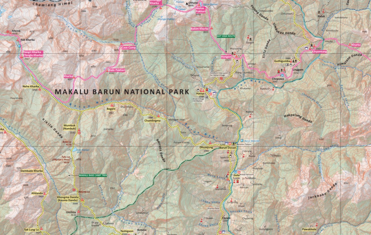
The latter section of the trek follows the route to Everest Base Camp, from where mountaineering expeditions set off to scale Everest. The trek also visits Gorakshep and Kala Patthar, the viewpoint for Everest, from where the views of the world’s tallest mountain are simply stunning! The Makalu Barun region is one of the largest protected areas in Nepal, home to 3,000 species of flowering plants, including a variety of Himalayan orchids, 440 species of birds, and 75 species of mammals. Rare species such as the snow leopard, musk deer, and Himalayan Thar live in this pristine environment. This is one of the reasons it has been included in the Sacred Himalayan Landscape initiative of the World Wildlife Fund (WWF).
And not forgetting the once-in-a-lifetime views of the immense mountain vistas of Makalu (8,481m), Everest (8,848m), and Lhotse (8,516m) – which are towering granite cliffs capped with amazing glaciers, and high altitude lakes. This is a journey for those who have the stamina and fitness level to tackle one of the most rewarding and challenging treks in Nepal. The final days of this amazing trip are spent in Namche Bazaar and Lukla – and that’s just the icing on the cake (Or the snow on the glacier!).
Highlights of the Sherpani Col Pass Trek
Sherpani Col Pass Trek Outline Itinerary
Day 1: Kathmandu To Tumlingtar (Flight), Drive to Chichila
Chichila – 1980 m / 6496 ft – 4 hrs
Your guide will collect you from your hotel and take you to catch your flight to Tumlingtar. Naturally he is coming with you,
If you didn’t have time for breakfast in your hotel, grab a coffee and snacks at the airport – maybe the last good coffee for a while!
The 50 minute flight takes you to the north east of the country into the Arun Valley. Look out for the mountains as you approach your destination: Malaku 8,463m / 27,765, Ganesh Himal 7,422 m / 24,350.3 ft and Mount Everest 8,848 m / 29,028.8 ft. You will also pass over the Kathmandu Valley and foothills.
At Tumlingtar board a public jeep to take you to Chichila, where you stay overnight.
You will meet your camping crew at Chichila. Strangers now but fast friends by the end of your trek!

Chichila
Day 2: Chichila To Num
Num – 1040 m / 3412 ft – 6 hrs
It’s the first day of your trek! Time to learn the rhythm of camping life also. After breakfast, while the crew take down the camp, you head off through forests of rhododendron, which bloom red in the spring.
Today the hike is moderate and very pleasant as you descend down to the Arun River and cross over the first of many suspension bridges.

Num
Day 3: Num to Seduwa
Seduwa – 1500 m / 4921 ft – 6 hrs
It’s a steep descent which greets you this morning. Hike down through forestlands to the Barun River and cross the suspension bridge.
As you are in the Makalu Barun National Park, you will have your permits checked after you ascend back up on the other side of the river. For every down there is an up in the Himalayas.

Seduwa
Day 4: Seduwa To Tashi Gaon
Tashi Gaon- 2100 m / 6889 ft – 5 hrs
Rhododendron forests are definitely a feature on the lower elevations of this trek. Did you know they are Nepal’s national flower?
Pass through the villages of Hindrungma and Rupisa and on to your overnight camp ground at Tashi Gaon.

Tashi Gaon
Day 5: Tashi Gaon To Khongma Danda
Khongma Dada – 3500 m / 11482 ft – 7 hrs
Now it’s getting interesting. The challenge is on! As you rise around 1,400 m / 4,593.1 ft the walking feels harder. To put it into perspective, you increased your elevation today by the same elevation as Kathmandu!
As compensation, the mountain views are stunning. You may stop for lunch at Dhara (which means tap), named after its natural spring water source. After a short break, there is a final ascent to Khongma Danda. Khongma Danda is a ridge with more breathtaking views of Chamlang, Peak 6, Makalu, and others.

Khongma Danda
Day 6: Acclimatization Day
Khongma Dada- 3500 m / 11482 ft – 2 hrs
For the next two weeks you are going to be at high altitude, so we give you an acclimatization day at Khongma Danda to prepare you for what is to come. Now is the time to really pay attention to your body, looking for any signs of altitude related illness.
There is time today to meet some of the Sherpas in this community, watch them in their daily lives, and know that not all Sherpas are mountaineers.
You will also by now be very familiar with the camping lifestyle you have adopted for this trek. Enjoy the camp environment and perhaps lend a hand preparing lunch. No pressure!
Machhermo
Day 7: Khongma Danda To Dobato
Dobato – 3500 m / 11482 ft – 6 hrs
Today you are going to cross two passes. Start off by walking along a ridge to the Ghungru La Pass at 4,055 m / 13,303.8 ft. Then trek on to another pass – Keke La Pass at 4,170 m / 13,681 ft. Neither of the passes are particularly high or hard to cross. Good practice for what is to come.
Beautiful mountain views from the top of the passes are a definite highlight.

Dobato
Day 8: Dobato To Yangla Kharka
Yangla Kharka – 3557 m / 11669 ft – 7 hrs
Start the day with a hike through a rhododendron forest to the Barun River. You will probably see yaks grazing in the pastures. Actually, you will overnight on a meadow – one which has amazing mountain views. Catch the stars and the mountains as the sun goes down. Does it get better than this?

Yangla Kharka
Yangla Kharka
Day 9: Yangla Kharka To Langmale Kharka
Langmale Kharka – 4410 m / 14468 ft – 6 hrs
This is another day when the altitude will rise by almost 1,000 m / 3,280.8 ft. In order to mitigate any possible altitude related problems, go easy today, take lots of breaks and stay well hydrated.
It’s a steep trail ascending through alpine meadows, meadows, forests and rhododendron forests.
Your camp tonight is on a summer pasture for yak herds. The mountains you can see there are Peak 3, Peak 4, Peak 5, Chamlang and Hongku Chuli. Quite astounding.

Langmale Kharka
Day 10: Langmale Kharka To Makalu Base Camp
Makalu Base Camp – 4870 m / 15977 ft – 6 hrs
Today you reach the first of four base camps on this trek! This one is a bit of a challenge but with determination you can do it.
The trail crosses moraine deposits, rocky land, potential snow and ice patches. Crampons may be needed. The rewards are, as always, stunning views, which are today of the Barun Glacier and snow-capped mountains.
When you reach Base Camp, Makalu, the 5th highest mountain in the world, is there in front of you. Part of the Mahalangur Himalayas, Malaku is 8,485 m / 27,838 ft in height and approximately 19 km / 12 miles southeast of Mount Everest.
Another interesting fact is you will see the Kangshung Face of Mt Everest first scouted by George Mallory in 1921 but only summited in 1982 by a Japanese expedition. This face is hardly ever seen by trekkers and is rarely scaled by mountaineers.
The statistics are mind-blowing!

Makalu Base Camp
Day 11: Makalu Base Camp to Swiss Base Camp
Swiss Base Camp – 5150 m / 16896 – 6 hrs
The trail follows the west side of the Barun Glacier until it meets lateral moraine. The trail is rocky, and you have to hike over slopes. There are fabulous views of Makalu’s ridges and Everest and Lhotse as you continue on this long day at high altitude.

Swiss Base Camp
Day 12: Acclimatization Day
Swiss Base Camp – 5150 m / 16896 ft – 3 hrs
You need to allow your body to adjust to the ever increasing altitude so here at Swiss Base Camp we give you the opportunity to rest, relax, explore.
Overnight at Swiss Base Camp – camping
Day 13: Swiss Base Camp to Sherpani Col Base Camp
Sherpani Col Base Camp – 5688 m – 18661 ft / 5 hrs
The trails are rugged, with loose scree today and care must be taken while hiking. The initial ascent takes you to the top of a valley then down to where the next camp will be set up.
The mountain landscape is equally as rugged, with astounding peaks surrounding you.
Although not a long trek today, it is at high altitude so on arrival at the camp, rest and prepare for an even higher ascent tomorrow.

Sherpani Col Base Camp
Day 14: Sherpani Col Base Camp to Baruntse Camp
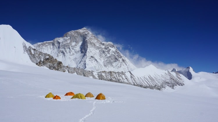
Baruntse Camp – 6050 m / 19849 ft – 8 hrs
This is the toughest day of the trek with not just one, but two mountain passes to cross: Sherpani Pass at 6,155 meters / 20,223 ft and West Col Pass at 6,143 meters / 20,154 ft.
To achieve this challenging journey, you leave before dawn and in that way avoid the late morning weather which is likely to be high winds and strong sun. The ascents are steep, and there will be snow and ice to negotiate. Crossing the Sherpani Pass there will be fixed ropes.
After crossing this pass, descend into the West Barun Glacier Valley and cross the West Col. From here descent to another glacier, the Hunku Glacier and on to Baruntse Camp.
Rehydrate, drink a hot drink and eat snacks with relish at your overnight camp!

Baruntse Camp
Day 15: Baruntse Camp to Honku Basin
Honku Basin – 5500 m / 18044 – 5 hrs
After a good night’s sleep and a hearty breakfast, you are traveling down to a much lower altitude today, which will definitely help you breath more easily.
You will see the high altitude Honku River today as well as glacial moraines and rocky trails.
Surrounded by the ever-present mountains, the camp site at Honku Basin is a wonderful location to spend the night.

Honku Basin
Day 16: Honku Basin to Amphu Laptsa Base Camp
Amphu Laptsa Base Camp – 5527 m / 18134 ft – 5 hrs
Today come to your third base camp – Amphu Laptsa Base Camp at 5,527 m / 18,134 ft.
Again, the trail is challenging with ice, rocks, boulders and scree. If you concentrate on the beautiful mountains and glaciers you will see today you can get through this day of testing your body to the limits.

Gola
Day 17: Acclimatization Day
Amphu Laptsa Base Camp – 5527 m / 18134 ft – 5 hrs
Today is a day to rest and relax after the tough trekking you have been doing. Conversely, you are also preparing your body for tomorrow’s final mountain pass challenge.
Do some gentle exercises and enjoy the surroundings. Perhaps see if there is anything you can do to help around the camp.
Overnight at Amphu Laptsa Base Camp – camping.
Day 18: Amphu Laptsa Base Camp to Chukung
Chukung – 4730 m / 15518 ft – 9 hrs
After your relaxing time at base camp, it’s another tough hike and another pass to cross today to reach Chuking. Once you have crossed over the Amu Lapcha Pass and entered the valley on the other side, you are in the Everest Region!
The views from the pass are of Ama Dablam, Lhotse Shar, Lhotse South Face and more.
Now you will begin to see many more trekkers on the trails as the Everest Region is famous for trekking and climbing – as you know.

Chukung
Day 19: Chukung to Tengboche
Tengboche – 3960 m / 12992 ft
This is an exciting day as you will visit places whose names are famous among even non-climbers.
Dingboche and Pangboche are Sherpa villages with a long history of culture and a somewhat shorter one in the tourism industry. Pangboche Monastery is the oldest monastery in the region. Pay a short visit to the monastery and marvel at the architecture.
Moving on to Tengboche, here you find the highest located monastery in the region, in the country even – Tengboche. From its grounds there are amazing panoramic views of Everest and other mountains in this region. Spend time in this monastery and perhaps attend the evening puja (religious ceremony) or the early morning one.
Day 20: Tengboche to Monjo
Monjo – 2700 m / 8858 ft
You will notice that the landscape is changing to become more green as you descend down through Sagarmatha National Park. There are some river crossings to do – using the long suspension bridges.
Today you will pass through Namche Bazaar and perhaps stop here for lunch and a great coffee (at last!).
You are almost at the end of your trek so do enjoy the stunning mountain views as you hike. Take in every moment that’s left.
Day 21: Monjo to Lukla
Lukla – 2840 m / 9317 ft
After breakfast set out on the last day of your trek passing through greenery, over rivers and down to the airport town of Lukla where you will wait for your morning flight.
It’s a sad day as you say goodbye to your camping crew but there is the hustle and bustle of Kathmandu to look forward to. And more good coffee! So, celebrate tonight with your guide and fellow trekkers.
Day 22: Lukla to Kathmandu (Flight)
Kathmandu – 1300 m / 4265 ft
Your flight today may be direct to Kathmandu, or it may be to the new airport for the Everest Region at Ramchhap in the Terai. If you are flying to Ramchhap you will have a bus journey of 4-6 hours along the lowland areas of the country then up through the foothills into the Kathmandu Valley.
In Kathmandu your guide will escort you to your hotel and say his final goodbye.
Not satisfied with this Itinerary?
Are you interested on planning custom trip? It only takes 2 minutes.
Includes
Veg
Wide variety of Vegeterian food is available on the trek
Vegan
Wide variety of Vegan food is available on the trek
Packing List for Sherpani Col Pass Trek
Items | Details | Quantity |
---|---|---|
Underwear | Underwear Breathable synthetic | 3 |
Socks | Wool BYO | 3 |
Bra | Sports BYO | |
Base layers – Pants | Merino wool BYO | 1 |
Trekking shirt | Synthetic lightweight BYO or purchase it in Kathmandu | 2 |
Rain pants | Synthetic lightweight Frogg Toggs are excellent | 1 |
Trekking pants | Synthetic lightweight BYO or purchase in Ktm | 2 |
Hiking Shoes/Boots | BYO Salmon Quest 4D or Xultra 3 or 4 | 1 |
Camp shoes | Down booties BYO or purchase in Ktm | 1 |
Gloves | One pair of thin merino wool. 2nd pair thick insulated | 2 |
Hat | Sun hat or peak cap with neck protection. BYO | 1 |
Down Jacket | BYO | 1 |
Wind Breaker | BYO | 1 |
Note: Sleeping bags and down jackets can be rented in Kathmandu, while all other trekking equipment can be easily purchased. We at Magical Nepal will assist you in getting all your essentials sorted, ensuring you’re well-prepared for your adventure.
Read Before your book, the Sherpani Col Pass Trek
The Sherpani Col Pass Trek is one of Nepal’s most challenging and technical treks, crossing three high-altitude passes over 6,000 meters. This trek involves glacier crossings, fixed ropes, and camping, and is best suited for experienced trekkers or mountaineers with prior high-altitude experience.
Accommodation is a mix of basic teahouses and remote camping, with no easy evacuation access in some sections. At Magical Nepal, we manage all permits, logistics, and safety with experienced staff—ensuring you’re fully supported on this demanding and unforgettable adventure.
The Sherpani Col Pass Trek starts from Tumlingtar, situated in the eastern part of the country, near the Tibet border.
You will be trekking through the Makalu Barun National Park with its stunning river valleys and high mountains, not to mention unique wildlife and bird population. Then, icing on the cake, you will be trekking through Sagarmatha National Park in the Everest Region, passing through some of the iconic Sherpa villages on your way down to Lukla and flying out from there
- Remote and Off-the-Beaten-Path: This is one of the most remote treks in Nepal, connecting the Kanchenjunga and Makalu regions. Expect long days, basic facilities, and a true wilderness experience.
- Camping Required: Teahouses are only available in lower villages. For higher sections near the pass, full camping support is essential—Magical Nepal provides all experience guide, porter, and cooks.
- Licensed Guide is Mandatory: Due to the remoteness and unmarked trails, trekking with a licensed guide is required—and highly recommended for your safety.
- No Network or WiFi: Don’t expect mobile signal or internet access beyond lower villages. Magical Nepal equips guides with satellite or radio communication for emergencies.
- Physical Fitness Needed: This trek includes long, steep ascents and descents. Good fitness and endurance are necessary for safe and enjoyable trekking.
- Flight Delays Possible: Domestic flights to Bhadrapur or Tumlingtar can be affected by weather. We recommend keeping some buffer days before your international departure.
- Best Seasons: Spring (March–May) and Autumn (September–November) offer the most stable weather and safest conditions. We do not recommend trekking during monsoon or winter.
This is a strenuous to extreme camping trek. Not only will you be hiking for 20 days, sometimes more than 6 hours per day, you will be climbing over 4 mountain passes and hiking and sleeping at very high altitudes (over 5,000 m / 16,404 ft)
It is a camping trek. Something people either love or hate. We assume if you are considering this trek, you love camping!
You should be very fit, with a high stamina level to successfully, and happily, complete this trek. Previous high altitude trekking experience will definitely stand you in good stead. Do not use this trek as your first camping experience – definitely try for something less remote, and at times challenging, for your first camp out.
There are very few larger settlements which can provide accommodation for trekkers in these remote areas, which is why we chose to camp instead.
At the campsite you will have a comfortable tent and sleeping mat. There will be a toilet tent and dining tent. The chef will have his kitchen tent from where he will prepare good, wholesome food and safe drinking water for you.
We will try to make your camping experience as comfortable as possible but it is the Himalayas and we cannot predict the weather!
Food at the Camp Sites
Breakfast, lunch, afternoon snacks, and dinner are provided.
The food our chef will make is very good but we find it a good idea to bring some comfort food like dried fruits and nuts, chocolate bars, power bars etc from home. Nothing beats a bar of chocolate with a cup of hot tea at 5,000 m / 16,404 ft after an exhausting day.
Possible Menu While Camping:
Breakfast may be porridge with bread (probably roti – a Nepali flat bread)
If available in nearby settlements, perhaps eggs are on the menu.
Lunch and dinner can be pasta, noodles, dal bhat (Nepali vegetable curry), pizza, etc.
Afternoon snack may be fried potatoes and popcorn.
We will not buy meat on the trail but will bring some canned meat / tuna fish. Please note there always vegetarian food available at every meal.
Tea/ coffee/ hot water is unlimited, with powdered milk and sugar. Unfortunately, the coffee will be instant; no espresso or cappuccino here.
We will not carry alcohol as we do not recommend its consumption at altitude. And its too heavy for our porters to carry. Same goes for soft drinks – too heavy to carry.
Drinking Water While Camping
The kitchen tent will provide you with boiled water for drinking. A Life straw is probably the best idea as it filters out some, not all, larger bacteria, and if you add sterilizing drops/ liquid to spring water it will be drinkable.
- Clothing for the cold at high altitudes.
- Portable solar panel (one which hooks onto your day pack) to recharge equipment.
- Headtorch with batteries and extra batteries.
- Medicines – any ones you take regularly plus items such as headache tablets, stomach tablets etc. And a small first aid kit.
- Four-season sleeping bag. This can be rented in Kathmandu.
- Toiletries in small, travel sized containers, and some clothes washing soap.
- Things for blisters and a few bandages in case of sprains.
- Nepali rupees in case there is something you wish to buy on the trek. There will be limited places to spend money on this trek but you will need money for donations at monasteries, and in the very few places that have a shop.
- Your favorite snacks from home.
Whose Carrying Your Gear?
Porters will be carrying the tents, kitchen equipment and food for this trek. It is also possible for them to carry your gear. Please be considerate and keep your gear down to a sensible weight of essentials!
It is the norm to tip your guide and porters on treks. For camping treks, you also have a camp chef who you should tip also.
This is a long trek with challenging terrain even for locals (which most of our porters are) when carrying weight. Your appreciation of these strong and amazing men is appreciated. Your guide is also working hard to keep you safe, supported, and informed. And you could not do this trek without the camp chef!
Please be aware, 100% of your tips go to the staff.
We suggest the following:
- Tip the guide 10% of your trip cost.
- For the porters, it is normal to tip around a total of USD150 for each porter.
- Tip the chef USD200 as the norm.
The tips for the guide and crew members are divided by the number of trekkers on a trip. The larger your group, the less you pay as an individual!
Want to read later?
Download the PDF and read it later.
Sherpani Col Pass Trek Map