Introduction to Makalu Base Camp Trek
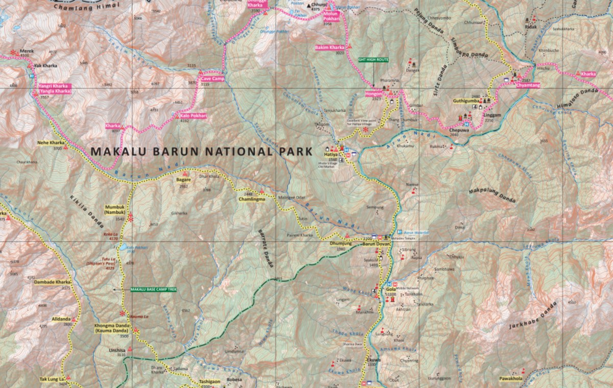
The Makalu Base Camp trek begins from Tumlingtar in the mid-eastern region. This is a high altitude trek, which takes in lower landscapes of lush rhododendron forests, picturesque Gurung villages, river valleys and the Makalu Barun National Park. At higher altitudes, there are breathtaking panoramas of the Himalayas, high altitude lakes, and passes to cross to reach the barn, rocky base camp.
This is a long, varied and quite a strenuous trek suitable for those who are keen trekkers and nature enthusiasts and who would rather be in tranquil, pristine nature than follow the crowds. Makalu Base Camp is situated at 5100m so the long trek through ever-increasing altitude is a great way to slowly acclimatize. The Makalu Base Camp trek begins from Tumlingtar in the mid-eastern region. This is a high altitude trek, which takes in lower landscapes of lush rhododendron forests, picturesque Gurung villages, river valleys and the Makalu Barun National Park.
At higher altitudes, there are breathtaking panoramas of the Himalayas, high altitude lakes, and passes to cross to reach the barn, rocky base camp. This is a long, varied and quite strenuous trek suitable for those who are keen trekkers and nature enthusiasts and who would rather be in tranquil, pristine nature than follow the crowds. Makalu Base Camp is situated at 5100m so the long trek through ever-increasing altitude is a great way to slowly acclimatize.
From base camp the Barun Glacier, the south face of Makalu (8,481m), and a complete panorama of Everest and Lhotse is seen. Time is given to trekkers to explore the lakes and glaciers around base camp before heading down from this icy, rocky land to green forests and valleys again. On the return journey trekkers cross the Tutu La Pass (4,125m) which is now known by the name of Shipton’s Pass.
The Shipton Pass is named after the renowned mountaineer Eric Shipton who was involved with most expeditions to Mount Everest in the 1930’s and who, in 1951, was part of the team that mapped out the now famous route over the Khumbu Glacier.
The Makalu Barun National Park is home to 3,000 species of flowering plants, 440 species of birds and 75 species of mammals including the snow leopard, red panda, musk dear, wild boar, wild yak and the Himalayan Thar. With the possibility of spotting wildlife at lower altitudes, green pastures and fields, villages, and forests, combined with snow-capped mountains, glaciers and rocky trails, this is also ideal photography territory!
Makalu Base Camp Trek Highlights
Makalu Base Camp Trek Outline Itinerary
Day 1: Kathmandu To Tumlingtar (Flight) to Chichila (Drive)
Chichila – 1980 m / 6496 ft – 4 hrs
Your guide will meet you after breakfast and take you to the domestic terminal of the Tribhuvan International Airport to board your plane for Tumlingtar.
This 50 minute flight takes you to the north east of the country into the Arun Valley. From the plane you are likely to see Malaku 8,463m / 27,765, Ganesh Himal 7,422 m / 24,350.3 ft and Mount Everest 8,848 m / 29,028.8 ft.
After touching down in Tumlingtar you board a public jeep to take you to Chichila, where you stay overnight.
Chichila Village
Day 2: Chichila To Num
Num – 1040 m / 3412 ft – 6 hrs
After breakfast, set off on your first trekking day. The trail gradually descends through lush forests of rhododendrons and bamboo. Be careful on the trail as it may be slippery in places, but overall, it’s a moderate and pleasant hike.
Crossing the Arun River, you come to your first suspension bridge of this trek.
Num
Day 3: Num to Seduwa
Seduwa – 1500 m / 4921 ft – 6 hrs
First thing in the morning you are faced with a steep descent out of Num through forestlands to the Barun River. Here is your second suspension bridge – why don’t you count how many you encounter on this trek?
After crossing the river there is a steep ascent which brings you into the Makalu Barun National Park. Here you will have your permits checked before you reach your overnight teahouse.
Seduwa
Day 4: Seduwa To Tashi Gaon
Tashi Gaon- 2100 m / 6889 ft – 5 hrs
It’s a beautiful hike through rhododendron forests, and cultivated farmlands today. There is another river to cross – and you guessed it – by suspension bridge! You will walk through two villages – Hindrungma and Rupisa before reaching Tashi Gaon.
Tashi Gaon
Day 5: Tashi Gaon To Khongma Danda
Khongma Dada – 3500 m / 11482 ft – 7 hrs
It’s a challenging day today as you are rising considerably in elevation. Coming out of Tashi Gaon you come to your first challenge – an uphill hike; first through rhododendron forests then through pastures. From here there is a panoramic view of the surrounding mountains.
One of the places you pass by is called Dhara, which means tap. So called because of the natural water source here. This is a good place to stop, rest and take lunch.
Then it’s another ascent to Khongma Danda, a ridge with more breathtaking views of Chamlang, Peak 6, and Makalu, among others.
Khongma Danda
Day 6: Acclimatization Day
Khongma Dada- 3500 m / 11482 ft – 2 hrs
Due to the high altitude, today you take an acclimatization day in Khongma Danda. From now on the altitude falls into the numbers where someone could potentially suffer from altitude related problems. Stay hydrated, take your time when hiking and listen to your body.
Have a leisurely breakfast then explore the village and surrounding countryside.
This, like others in the area, is a Sherpa village so this is your opportunity to learn something about Sherpa culture and lifestyle.
Machhermo
Day 7: Khongma Danda To Dobato
Dobato – 3500 m / 11482 ft – 6 hrs
Today you are going to cross two passes, which can be quite a challenge if you are not prepared. Your first pass comes after walking along a ridge – Ghungru La Pass at 4,055 m / 13,303.8 ft. Then trek on to another pass – Keke La Pass at 4,170 m / 13,681 ft. After some time reach the village of Dobato which is situated in a valley.
Although you are crossing two mountain passes, neither of them are particularly high so you should enjoy the hike and the stunning mountain views from the top of the passes.
Dobato
Day 8: Dobato To Yangla Kharka
Yangla Kharka – 3557 m / 11669 ft – 7 hrs
More beautiful rhododendron forests to pass through today on your way to the Barun River.
If you haven’t seen them before on this trek, today is the day you will see yaks grazing in green pastures. Yangla Kharka itself is a meadow with stunning mountain views.
Yangla Kharka
Day 9: Yangla Kharka To Langmale Kharka
Langmale Kharka – 4410 m / 14468 ft – 6 hrs
You will rise in elevation by almost 1,000 m / 3,280.8 ft today so you must go slowly and take lots of breaks on the trail. Most definitely you will be feeling some slight changes in your body, which is only natural. But do look out for more serious or long lasting symptoms.
The trail is steep as you ascend through alpine meadows, forests and rhododendron forests. You will be crossing more pastures, where there may be herds of yaks.
You will be staying at Langmale Kharka, which is a summer pasture for yak herds, with stunning views of Peak 3, Peak 4, Peak 5, Chamlang and Hongku Chuli.
Langmale Kharka
Day 10: Langmale Kharka To Makalu Base Camp
Makalu Base Camp – 4870 m / 15977 ft – 6 hrs
Today you reach base camp! But it’s a difficult hike to get there – are you up to the challenge?
The trail crosses moraine deposits, rocky land, potential snow and ice patches. The Barun Glacier and snowy mountains are all around you. Travel slowly and carefully over the loose rocks and slippery trails. It may be that crampons are needed in parts.
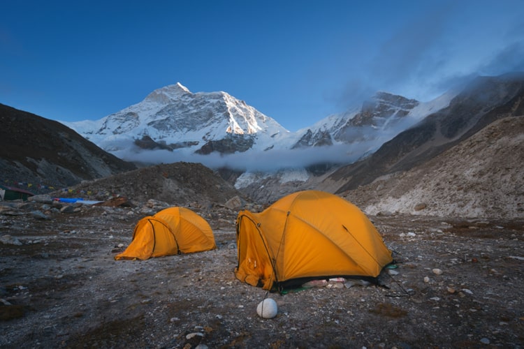
After negotiating switchback trails you reach a plateau. And there it is in front of you – the 5th highest mountain in the world! Malaku is 8,485 m / 27,838 ft tall – hard to imagine this is only the 5th highest mountain. As part of the Mahalangur Himalayas, Malaku is approximately 19 km / 12 miles southeast of Mount Everest. We assume that is as the crow-flies and not as the trekker hikes! It sits on the Nepal / China border, as does Everest.
Overnight at Makalu Base Camp – teahouse.
Makalu Base Camp
Day 11: Explore Makalu Base Camp
Makalu Base Camp – 4870 m / 15977 – 3 hrs
There is plenty of time to explore base camp today and take photographs and videos for those back home.
There are many mountains to see today. And by hiking a short distance (around 3 hours return trip) you can climb a ridge to get the best possible views of the mountains, glaciers and lakes. Apart from Malaku (now sitting right in front of you), you will see Chamlang (7,319 m / 24,012.4 ft), Lhotse (8,516 m / 27939.6 ft) and the Kangshung Face of Everest.
Did you know, the Kangshung Face of Mt Everest was first scouted by George Mallory in 1921 but only summited in 1982 by a Japanese expedition? This side of Everest is known for its remoteness, steeper ascents and more technical terrain than the more famous South Col and Northeast Ridge routes to the summit. It is on the Tibet side of Everest and rarely seen, or even heard of, by mountaineers or trekkers. On this trek, you get to see it clearly!
Day 12: Makalu Base Camp To Yangla Kharka
Yangla Kharka – 3557 m / 11669 ft – 7 hrs
After breakfast you are going to retrace your steps back to Langmale Kharka, this time descending from base camp instead of hiking upwards.
After crossing Langmale Kharka descend to the Barun River Valley until you reach Yangle Kharka. This stretch of the trail sees more vegetation in the form of juniper forests and rhododendrons. Keep an eye out for birds on this part of the trail, which leads you to a wide valley and seasonal yak pastures.
Day 13: Yangla Kharka to Dobato
Dobato – 3500 m / 11482 ft – 7 hrs
Vegetation gets even more dense today as you go down and along the Barun River Valley. The hiking is more gentle so you can really enjoy the views of Makalu,
Chamlang and the other mountains. Learn something about the lifestyle of the villages you are passing through.
Day 14: Dobato To Khongma Danda
Khongma Danda – 3500 m / 11482 ft – 6 hrs
Retrace your steps today back to Khongma Danda.
As you cross the two passes – Ghungru La Pass at 4,055 m / 13,303.8 ft and Keke La Pass at 4,170 m / 13,681 ft – take note if you find these easier now than on the inward journey. Perhaps because you have been at high altitude for some days, crossing over the passes comes more easily.
At the top of each pass, stop and admire the surrounding mountains – have they changed in any way, or is it your perspective?
Day 15: Khongma Danda to Tashi Gaon
Tashi Gaon – 2100 m / 6889 ft – 5 hrs
Today you are going down in elevation so your breathing will be easier and your walking lighter. Hiking through the now familiar rhododendron forests and grazing pastures, the mountains are still with you as you approach Tashi Gaon.
Something you may not have noticed/ registered on the inward journey is that the teahouses at Tashi Gaon are a little above the others in terms of facilities and offer charging facilities and hot showers. Enjoy your night in the dining room chatting with other trekkers.
Day 16: Tashi Gaon to Seduwa
Seduwa – 1500 m / 4921 ft – 5 hrs
Take your time over breakfast this morning as it’s a shorter day on the trail. Say hello again to the villages of Hindrungma and Rupisa on your homeward journey to Seduwa.
By now you find crossing suspension bridges easy and do so with confidence!
There is plenty of cultivated farmland on show as the altitude is low enough to support many types of crops.
Day 17: Seduwa to Num
Num – 1040 m / 3412 ft – 5 hrs
This is your final hiking day on this trek. With a touch of sadness, you pass over that original first suspension bridge crossing the Arun River.
Day 18: Num to Chichila to Tumlingtar (Drive)
Tumlingtar – 1980 m / 6496 ft – 7 hrs
Today take a local jeep to Chichila and most likely change jeep to head towards Tumlingtar where you overnight while waiting for your morning flight to Kathmandu.
Tumlingtar
Day 19: Tumlingtar To Kathmandu (Flight)
Kathmandu – 1300 m / 4265 ft – 50 min
Your flight takes you out of the Makalu area and back to the capital of Kathmandu. Enjoy your last sight of the mountains out of the plane window.
On arrival in Kathmandu, your guide will escort you back to your hotel and say a sad goodbye.
Not satisfied with this Itinerary?
Are you interested on planning custom trip? It only takes 2 minutes.
Includes
Veg
Wide variety of Vegeterian food is available on the trek
Vegan
Wide variety of Vegan food is available on the trek
Packing List
Note: Sleeping bags and down jackets can be rented in Kathmandu, while all other trekking equipment can be easily purchased. We at Magical Nepal will assist you in getting all your essentials sorted, ensuring you’re well-prepared for your adventure.
Items | Details | Quantity |
---|---|---|
Underwear | Underwear Breathable synthetic | 3 |
Socks | Wool BYO | 3 |
Bra | Sports BYO | |
Base layers – Pants | Merino wool BYO | 1 |
Trekking shirt | Synthetic lightweight BYO or purchase it in Kathmandu | 2 |
Rain pants | Synthetic lightweight Frogg Toggs are excellent | 1 |
Trekking pants | Synthetic lightweight BYO or purchase in Ktm | 2 |
Hiking Shoes/Boots | BYO Salmon Quest 4D or Xultra 3 or 4 | 1 |
Camp shoes | Down booties BYO or purchase in Ktm | 1 |
Gloves | One pair of thin merino wool. 2nd pair thick insulated | 2 |
Hat | Sun hat or peak cap with neck protection. BYO | 1 |
Down Jacket | BYO | 1 |
Wind Breaker | BYO | 1 |
Kathmandu to Timlingtar Flight
The flight from Kathmandu to Tumlingtar is the quickest way to reach the start of the Makalu Base Camp Trek, but it’s not always reliable. Weather conditions often cause delays or cancellations, especially during the monsoon and winter seasons. At Magical Nepal, we plan for such disruptions and arrange backup transport by jeep if needed. We recommend allowing extra days in your itinerary and booking flexible international flights to avoid stress.
Read before your book, Makalu Base Camp Trek
The Makalu Base Camp Trek is a challenging and remote adventure, ideal for experienced trekkers. Expect basic teahouses, camping at high altitudes, and long, rugged hiking days.
Flights to Tumlingtar are often delayed, so it’s essential to be flexible. Magical Nepal handles all logistics, safety, and support, so if you’re ready for a true wilderness trek, we’re here to guide you every step of the way.
The Makalu Base Camp Trek is a strenuous adventure, best suited for experienced trekkers and those with a high level of physical fitness. While it does not require technical climbing skills, the challenging terrain, remote trails, high altitude, and long trekking days make it a demanding journey. Here’s a breakdown of the trek’s difficulty factors.
Altitude & Acclimatization
One of the biggest challenges of the Makalu Base Camp Trek is the high altitude. The trek takes you above 5,000 meters (16,400 feet), with the highest point reaching 5,100 meters (16,732 feet). As you ascend, oxygen levels drop, increasing the risk of altitude sickness (AMS). Proper acclimatization, hydration, and maintaining a steady pace are essential to minimizing the risk of AMS.
Key High-Altitude Points:
- Shipton La Pass (4,125m / 13,533ft) – First major pass crossing
- Keke La Pass (4,170m / 13,681ft) – Another high pass on the route
- Yangla Kharka (3,557m / 11,669ft) – Important stop before higher altitude gain
- Langmale Kharka (4,410m / 14,468ft) – Acclimatization point before Base Camp
- Makalu Base Camp (5,100m / 16,732ft) – Highest point of the trek
Trekking Duration & Daily Walking Hours
The Makalu Base Camp Trek typically takes 19 days, with an average of 5-7 hours of walking per day. The trails feature both steep ascents and descents, demanding a high level of endurance and stamina. Proper physical preparation is essential to successfully complete this strenuous journey.
Challenging Sections:
- Num to Seduwa – Steep descent to the Arun River followed by a challenging ascent
- Tashi Gaon to Khongma Danda – Strenuous uphill climb through forests and ridges
- Khongma Danda to Dobato – Crossing multiple high passes with steep ascents and descents
- Makalu Base Camp Push – A tough trek over rocky moraine and glacier sections with limited oxygen, but stunning panoramic views of Makalu, Everest, and Lhotse
Terrain & Trail Conditions
The Makalu Base Camp Trek features a mix of forested trails, rugged mountain paths, steep ascents and descents, high mountain passes, and glacial moraines. The section from Tashi Gaon to Khongma Danda is particularly strenuous due to the continuous uphill climb, while the final ascent to Makalu Base Camp involves trekking over loose moraine and rocky terrain at high altitude.
During winter (December to February), snow and ice can make the higher sections slippery and challenging, while the monsoon season (June to August) brings heavy rain, landslides, and swollen rivers, making the trail more difficult to navigate.
Physical Fitness & Preparation
While no technical climbing skills are required, a high level of physical fitness and endurance is necessary to complete this demanding trek. Recommended training includes:
- Cardio workouts (hiking, running, cycling)
- Leg strength exercises (squats, lunges, step-ups)
- Endurance training (long-distance hikes with a loaded backpack)
Prior trekking experience in high-altitude conditions is highly recommended due to the remote nature and challenging terrain of the Makalu region.
The Makalu Base Camp Trek is classified as strenuous, primarily due to high altitude, long trekking days, and steep ascents over passes. However, with proper acclimatization, fitness preparation, and mental resilience, it is a highly rewarding trek offering breathtaking Himalayan panoramas, remote landscapes, and rich biodiversity.
Best for: Ideal for fit, experienced trekkers seeking a challenging, off-the-beaten-path adventure with stunning views of Makalu, Everest, and Lhotse.
Not ideal for: The Makalu Base Camp Trek is not ideal for beginners, those sensitive to altitude, or trekkers seeking easier, well-facilitated trails.
- Daytime temperatures range from 10°C to 20°C (50°F to 68°F) at lower elevations, though it gets colder as you ascend higher.
- blooming rhododendron forests, which paint the trail with vibrant reds, pinks, and whites.
- The skies are generally crystal clear, offering breathtaking views of Makalu, Everest, Lhotse, and Baruntse.
- Autumn (late September to November) offers stable weather and excellent visibility, with post-monsoon skies perfect for panoramic Himalayan views.
- Daytime temperatures range from 10°C to 15°C (50°F to 59°F) at lower elevations, while higher altitudes can get quite cold, especially at night.
- The trails are dry and firm, with minimal risk of landslides, making it one of the safest and most comfortable times to trek.
- Blue skies and snow-capped peaks attract more trekkers during this season—book early with Magical Nepal to secure the best logistics and accommodations.
- Winter offers a quiet, crowd-free experience, with stunning snow-covered peaks, frozen lakes, and dramatic mountain scenery.
- Daytime temperatures range from -10°C to 5°C (14°F to 41°F) at higher elevations, with nights dropping well below freezing. Despite the cold, skies are generally clear and bright.
- Heavy snowfall and icy trails can make trekking more difficult, especially in remote high-altitude sections of the route.
- This season is best for seasoned trekkers with proper winter gear and preparation. Magical Nepal ensures safety with trained staff and customized cold-weather support.
- Heavy rain: Causes slippery trails, leeches, and poor visibility.
- Landslides & floods: Risky trail sections, especially in forested and river-crossing areas.
- Flight delays: Kathmandu–Tumlingtar flights often canceled.
- Cloudy views: Limited or no mountain visibility.
- Lush greenery: Forests and hills are vibrant and fresh.
- Fewer trekkers: Trail is peaceful and uncrowded.
- Local interaction: Better chance for cultural exchange in quiet villages.
The best seasons to trek to Makalu Base Camp are spring (March to May) and autumn (late September to early November). These periods offer the most favorable weather, clearer skies, and more stable trail conditions for high-altitude trekking.
Spring Season (March to May)
Why it’s ideal:
- Clear mountain views: Crystal-clear skies offer stunning panoramas of Makalu, Everest, Lhotse, and Baruntse.
- Blooming rhododendrons: Lower sections of the trail, especially around Tashi Gaon and Khongma Danda, are vibrant with blooming flowers.
- Moderate temperatures: Daytime weather is warm in lower elevations and tolerable at higher altitudes.
- Dry trails: Snow begins to melt in higher sections, making passes like Shipton La more accessible.
Things to consider:
- Some snow may still linger in early March at higher altitudes.
- Popular among both local and international trekkers—teahouses may be busier than in the off-season, though this trek is generally less crowded.
Autumn Season (Late September to Early November)
Why it’s ideal:
- Post-monsoon clarity: Trails are clean, the air is fresh, and visibility is at its best.
- Stable weather: Low chances of rainfall or snowfall, making it the safest time to cross high passes like Shipton La.
- Cultural highlights: Major festivals like Dashain and Tihar fall in this period, offering a chance to experience local culture in villages like Tashi Gaon or Seduwa.
Things to consider:
- Nights and early mornings can be colder than in spring, especially above 3,500 meters.
- Because of the stable conditions, this is often the most recommended time by guides and agencies.
Seasons to Avoid
Winter (Late November to February): Harsh cold, snowfall, and the closure of high passes (like Shipton La) make trekking difficult and risky.
Monsoon (June to early September): Heavy rainfall, leeches, landslides, and poor visibility make trekking dangerous and unpleasant.
Makalu Barun National Park Entry Permit
Where to get it: Nepal Tourism Board office in Kathmandu or the park entrance in Seduwa.
Cost: NPR 3,000 per person (approximately USD 30) for foreign nationals, plus a small additional government tax.
Why you need it: The trek passes through Makalu Barun National Park, a protected area requiring permits for entry.
Makalu Rural Municipality Permit
Where to get it: Issued in Khandbari or Tumlingtar before entering the trekking route.
Cost: NPR 2,000 per person (approximately USD 20).
Why you need it: Makalu Rural Municipality enforces this local permit for trekkers entering the Makalu region.
Practical Tips
Trekking with a Guide – Recent regulations in Nepal encourage trekkers to hire a licensed trekking guide. While not strictly enforced in all areas, having a guide can help navigate permit procedures and ensure a safer journey.
Carry your permits at all times – You’ll need to show them at various checkpoints along the route.
Keep extra copies of your passport and photos – These can save you time if you need to re-issue any permits or if additional documentation is required.
Stay updated – Local rules and fees can change without much notice. Always verify costs and regulations with your trekking agency or through official government sources before heading out.
Included in the cost of your trek are breakfast, lunch, and dinner. Breakfast and dinner will also include tea, and coffee when it is available. Drinking water, soft drinks, beer or extra food are not included and you should pay directly to the teahouse.
On the trek, breakfast and dinner are taken in the teahouses where you sleep, and lunch is taken on the trail at a smaller teahouse. If the guide knows there is no small eatery on that day’s trail, he will arrange packed lunches for you.
This is not a heavily trekked area. As a result, teahouses are more basic, as too are their menus. Food is plentiful and tasty but there is not a lot of Western choices on the menu. Some of the more established and busy trekking routes in other parts of the country get training on preparing Western foods. Not so in this more remote area.
Sources of Water on the Trek
It should go without saying to experienced trekkers, do not drink the tap water or natural spring water untreated or unfiltered. Purifying drops or tablets can be added to the water which will then make it safe for drinking.
You can also bring a Lifestraw from home as a backup and to filter out any unwanted particles. It is not guaranteed there will be bottled water in the teahouses. Boiled drinking water is available, but you have to pay for that. We recommend that even if bottled water is available, in order to preserve the countryside, you do not purchase it. Getting rid of plastic bottles is a challenge in mountain areas.
Tips on Water:
To avoid dehydration, drink 4ltr of water per day. Hot newly boiled water will be a treat in the cold mornings as you start your trek. Your stainless steel water bottle full of hot water will warm you in bed at night and can be drunk cold during the day.
Porridge
Tibetan bread
Pancakes
Tea
Chapatis
Garlic Omelets
Boiled Eggs
Boiled Potato
Tibetan bread
Omlet
Tea
Dal Bhat
Rice, lentils & veggies
Momo
Tibetan dumplings
Thukpa
Noodle soup
Chowmein
Fried noodles
Macaroni/Pasta
With egg or vegetables
Soups
Vegetable, garlic
Fried Rice
With egg, vegetables, or tuna
Noodles
with Vegetable, Egg
Fried Rice
With egg or vegetables
Curry
Vegetable, Egg, Potato
- Western Foods are limited in the region.
- Expect a simple yet hygienic meal.
Altitude Challenges: The Makalu Base Camp Trek reaches an altitude of 5,100 meters (16,732 ft), making acclimatization crucial for a safe and enjoyable experience. The risk of Altitude Sickness (AMS) increases as you ascend, so it’s essential to pace yourself, stay hydrated, and listen to your body. The trek itinerary is designed with gradual altitude gains and rest days to help trekkers adjust naturally. Watch for early signs of AMS, including headaches, nausea, and dizziness, and descend if symptoms worsen.
Guides: Makalu’s trails are remote, rugged, and less traveled than popular trekking routes, making it highly advisable to trek with an experienced guide. A guide is more than just a navigator—they ensure your safety, monitor altitude symptoms, and share their deep knowledge of the mountains and local culture. In this untouched wilderness, having a guide enhances both security and experience.
Weather Preparedness: The weather in the Makalu region can be unpredictable, shifting from clear blue skies to sudden snowfall. Carrying layered clothing, a warm sleeping bag, and reliable trekking gear is essential to staying comfortable. Checking the weather forecast daily helps in planning each day’s trek efficiently. With proper preparation, you’ll be ready to embrace the elements and enjoy the journey, no matter the conditions.
By keeping these safety measures in mind, trekkers can immerse themselves fully in the stunning landscapes of Makalu, worry-free and ready for adventure.
The Makalu Circuit Trek offers some of the most dramatic and untouched landscapes in the Himalayas. Starting from the lowlands of Num and Seduwa, the trail takes you through lush tropical forests, terraced farmland, and traditional Rai villages before ascending into dense rhododendron, fir, and cloud forests.
As you climb higher, the scenery changes into alpine meadows, glacial valleys, and rugged high-altitude terrain, with jaw-dropping views of Mount Makalu (8,485 m / 27,838 ft) and neighboring peaks like Chamlang, Baruntse, and Everest. The Sherpani Col and Amphu Labtsa crossings (on extended versions of the trek) add even more extreme and remote Himalayan beauty.
The trek passes through the Makalu Barun National Park, a protected and biodiverse area that is home to some of Nepal’s rarest wildlife. Trekkers might spot red pandas, Himalayan black bears, snow leopards, musk deer, Himalayan thars, and langurs. The park also shelters over 400 species of birds, including the striking Himalayan monal, Nepal’s national bird.
With its mix of tropical jungles, high mountain passes, and remote valleys, the Makalu Circuit Trek offers an unmatched natural experience for those seeking solitude, raw wilderness, and wildlife in its natural habitat. Magical Nepal ensures that your journey is not only scenic but also respectful of the fragile ecosystems you’ll be exploring.
Want to read later?
Download the PDF and read it later.