Introduction to Tashi Lapcha Pass Trek
The Rolwaling Tashi Lapcha Pass trek goes through the Gauri Shankar Conservation Area and the Sagarmatha National Park, linking the Rolwaling Valley with the Everest region.
This trek will visit the beautiful Tso Rolpa Lake (4183 m), summit the Tashi Lapcha Pass (5682 m), visit Namche Bazaar, and offers superb breathtaking views of Gauri Shankar and Everest, and many other mountains. The Tashi Lapcha Pass is perhaps the most difficult in this region, so a high level of fitness and stamina is required.
This is reportedly one of the possible routes that people from Kham in Tibet used during the mid-1800’s. These people subsequently settled in this area and the Everest region and are now known as Sherpa. Therefore, this trek also has historical and cultural significance. After crossing the pass and coming into the Everest region, there are glorious views of Mount Everest, Nuptse, Lhotse, Ama Dablam, Thamserku and Kusum Kangaru. And once reaching the bustling market town of Namche Bazaar there is an opportunity to interact with other trekking and climbing groups as well as the Sherpas.
But before that, aside from perhaps spotting a snow partridge or two, and coming across herds of yaks (or more specifically, naks) producing milk for cheese making, don’t forget to look out for the fabled Yeti. It was on the slopes of the Rolwaling Peak that Eric Shipton photographed Yeti footprints in 1951!
This trek certainly combines history and culture with stunning mountain views, and the satisfaction of crossing a high Himalayan pass.
Tashi Lapcha Pass Trek Highlights
Tashi Lapcha Pass Trek Itinerary
Day 1: Kathmandu to Shigati (Drive)
Shigati – 950 m / 3116 ft
After an early breakfast, your guide will collect you from your hotel to take you to the bus station to board a public bus to Shigati.
The road follows the Araniko Highway and the Bhote Koshi and Sun Koshi Rivers. There is a good chance you will see whitewater rafters having their own adventure on the rivers.
Mount Gaurishankar can be seen in the distance as you make your way along the winding, and sometimes bumpy road. When you arrive at Shigati you will meet your camping crew who will be traveling and taking care of you over the coming days.
Day 2: Shigati to Jagat
Jagat – 1050 m / 3444 ft
A day of firsts: after your first night in your tent and your first breakfast, set out on the first day of your trek.
Today make your way along the Tama Koshi (river) and cross your first suspension bridge. Although today is a relatively easy day, there are a number of ascents and descents to introduce you to trekking in the Nepal Himalayas. You will get a better view of Gaurishankar (7,134m / 23,405.5 ft), the dominant peak in this area.
The people of the Rolwaling Valley are a mix of Gurung, Tamang, Magar and Sherpa, all of whom are Buddhist. There are also Brahmin and Chhetri people who are Hindu. Tonight, in the village of Jagat you will get an opportunity to see how people live in this area.

jagat
Day 3: Jagat to Simi Gaun
Simi Gaun – 1900 m / 6233 ft
As you will quickly learn, for every ascent there is a descent, and for every river there is a bridge, oven as suspension bridge!
Stunningly, for every river and stream on this trek there is a magical waterfall. Definitely these falls add to the tranquility of being in this remote area. On the down (no pun intended) side there are a great deal of stone steps on the trails in this area and you come across one today.
Pastures and terraced fields meet you around the village of Chhetchhet, as do Buddhist artifacts such as prayer flags and small shrines.
Wonderful views of Gaurishankar can be seen from the village of Simi Gaun – your overnight stop.

simi gaun
Day 4: Simi Gaun to Gyalchen
Gyalchen – 3300 m / 10826 ft
From here on the trek becomes more challenging. There are a lot of stone steps to climb and narrow paths, some with loose scree. The altitude rises today by approximately 1,400 m / 4,593 ft.
We consider the 3,000 m / 9,842.5 ft plus range to be when we need to start thinking about altitude related problems. So, from today, please pay close attention to any changes in your body.
Day 5: Gyalchen to Beding – Beding
Beding – 3650 m / 11975 ft
While Day 4 was a hard one, today is a lot less strenuous and the trails wider.
There is the opportunity to see grazing yaks and witness small seasonal herders’ settlements.
There are increasingly more Buddhist artifacts such as mani walls (walls with prayers carved into the stone) and prayer flags. There are two monasteries in the village of Beding. One which is located up on the hillside, and a newer one much closer to the village.

Beding
Day 6: Beding to Na Gaun
Na Gaun – 4100 m / 13451 ft
After breakfast, hike uphill to the Rolwaling River to where the valley widens into a U shape. Another great peak you will see from today onwards is Dorje Lakpa.
Again, you will climb up in elevation so remember to drink plenty of water and go slowly but steadily.
Arriving at Na Gaun you will find a beautiful village with traditional stone walls to protect the inhabitants and livestock from both wind and wild animals.

Na Gaun
Machhermo
Day 7: Acclimatization Day
Na Gaun- 4100 m / 13451 ft
Today, there is a chance to rest and relax while your body get used to the high altitude. Being active does help in this process so do explore the village and the surroundings. You can hike towards the Yalung Glacier to get better views of the glacier and the mountains of Yalung, Menlung and Gaurishankar.
Day 8: Na Gaun to Tso Rolpa Lake
Tso Rolpa Lake – 4183 m / 13723 ft
Today you arrive at the wonderful Tsho Rolpa Lake. This glacial lake is set in a stunning setting, surrounded by mountains, snow and ice. From a ridge above the lake you can take the most amazing photographs with the lake standing out in turquoise against the grey rocks and white snow.

Tso Rolpa Lake
Day 9: Acclimatization Day
Tso Rolpa Lake – 4183 m / 13723 ft
There is another day to acclimatize at this high altitude in order to make sure your body can cope with the thin area. So, take the time to learn something about the area, interact with your camping crew, talk with your guide, edit your photographs and simply enjoy your time at this amazing location.
Did you know Tsho Rolpa Lake is Nepal’s largest glacier lake? It is approximately 3.5 km / 2.17 miles in length and covers an area of 1.6 km / 1 mile. With a depth of around 132 m / 433 ft, it is also a deep lake whose waters continue to rise due to climate change.
During the winter the lake freezes completely and all year round it is quite cold in this area due in part to the high winds.
Day 10: Tso Rolpa Lake to Tso Rolpa Phedi
Tso Rolpa Phedi – 5682 m / 18641
Following the Mera Glacier to Mera Le Pass, we push on to High Camp over rock-strewn trails. Camp is set up at Mera High Camp in anticipation of the climb.
Day 11: Acclimatization Day
Tso Rolpa Phedi- 5682 m / 18641
With the now high altitude, you take another acclimatization day at Tsho Rolpa Phedi.
Enjoy the beautiful mountain vistas, and if the weather is just right you may be able to see some of the peaks in the Everest Range.
Day 12: Tso Rolpa Phedi to Ngole via Tashi Lapcha Pass
Ngole – 4,180m (13,713 ft)
This is a long and tough day, so you will start early in the morning in order to safely cross the pass and reach your overnight destination before dusk.
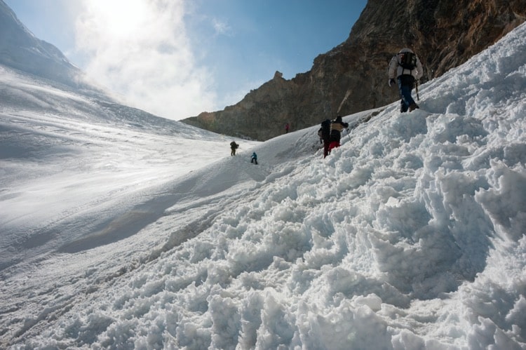
Following the glacier the trails may be slippery with ice and snow as well as scree as you ascend up the pass. There are fixed ropes on some parts of the crossing and great care should be taken – listen to your guide for instructions.
Descending is often more tricky than ascending Himalayan passes as the moraine can be loose and the descent hard on the body.
From the top of the pass there are glorious views of the surrounding peaks, making it all worthwhile. And you have now passed out of the Rolwaling Valley and have reached the Khumbu (Everest) region.
Coming down the pass, you will camp near Ngole village.
Day 13: Ngole to Thame
Thame – 3820 m / 12532 ft
The altitude is decreasing today, making it easier to hike, but care should still be taken to look out for any signs of altitude-related illness. Overall, it is a not too strenuous trek.
As you are now in the Everest Region, there are many signs that you are in a famous region of Nepal. There are small settlements to pass with their Buddhist artifacts and Tibetan-like architecture. You may wish to visit Thame monastery if time allows.
Day 14: Thame to Namche Bazaar
Thame – 3820 m / 12532 ft
Today you will be joining many of the main trekking routes through this region and reaching the famous market town of Namche Bazaar.
This is a fabulous hike today with so much history in the region. For example, Thame is the home village of Apa Sherpa who until recently was the world record holder for Everest summits.
On reaching Namche Bazaar you might want to head straight for a great espresso or beer at one of the many restaurants and cafes. Don’t forget you will still be camping tonight so remember to leave room for your campsite dinner!

Namche Bazar
Day 15: Namche Bazaar to Lukla
Lukla- 2860 m / 9383 ft
Today you will be joining many of the main trekking routes through this region and reaching the famous market town of Namche Bazaar.
This is a fabulous hike today with so much history in the region. For example, Thame is the home village of Apa Sherpa who until recently was the world record holder for Everest summits.
On reaching Namche Bazaar you might want to head straight for a great espresso or beer at one of the many restaurants and cafes. Don’t forget you will still be camping tonight so remember to leave room for your campsite dinner!

Lukla
Day 16: Lukla to Kathmandu (Flight)
Kathmandu – 1380 m / 4527 ft
Say your final goodbyes to your camp crew and board your plane back to the city. Flying over the mountains, foothills, and into the Kathmandu Valley is quite a sight and a fitting end to a great adventure.
Your guide will ensure you reach your hotel in Kathmandu and perhaps you will meet him again for a proper farewell later in the day.
Note: Depending on the season, you may fly directly to Kathmandu, or you may fly to Ramechhap then travel by road for around 5 hours to Kathmandu.
Not satisfied with this Itinerary?
Are you interested on planning custom trip? It only takes 2 minutes.
Includes
Veg
Vegetarian food is available on the trek.
Vegan
Vegan food is available on the trek.
Packing List for Mera Peak Climbing
Items | Details | Quantity |
---|---|---|
Underwear | Underwear Breathable synthetic | 3 |
Socks | Wool BYO | 3 |
Bra | Sports BYO | |
Base layers – Pants | Merino wool BYO | 1 |
Trekking shirt | Synthetic lightweight BYO or purchase it in Kathmandu | 2 |
Rain pants | Synthetic lightweight Frogg Toggs are excellent | 1 |
Trekking pants | Synthetic lightweight BYO or purchase in Ktm | 2 |
Hiking Shoes/Boots | BYO Salmon Quest 4D or Xultra 3 or 4 | 1 |
Camp shoes | Down booties BYO or purchase in Ktm | 1 |
Gloves | One pair of thin merino wool. 2nd pair thick insulated | 2 |
Hat | Sun hat or peak cap with neck protection. BYO | 1 |
Down Jacket | BYO | 1 |
Wind Breaker | BYO | 1 |
Note: Sleeping bags and down jackets can be rented in Kathmandu, while all other trekking equipment can be easily purchased. We at Magical Nepal will assist you in getting all your essentials sorted, ensuring you’re well-prepared for your adventure.
Kathmandu to Lukla Flight
Due to recent government regulations, there are no direct flights from Kathmandu to Ramechap. As a result, we must undertake a six-hour drive from Kathmandu to Ramechap. Since there are no good hotels in the area, we will need to depart at 1:00 AM to catch our flight to Lukla from Ramechap.
Read Before your Tashi Lapcha Trek
The Tashi Lapcha Pass Trek is remote, technical, and physically demanding, best for experienced trekkers. It includes camping, glacier crossings, and no network in high areas.
Magical Nepal provides all permits, gear, and expert support for a safe and unforgettable journey.
You will be trekking through the Rolwaling Valley, in east Nepal. The valley itself is situated in the Gaurishankar Conservation Area which links the two national parks of Langtang National Park and Sagarmatha National Park. The pass also brings you from Rolwaling into the Khumbu, as the Everest Region is known locally.
The trails take you through stunning landscapes of flora and fauna. In fact, within the Gaurishankar Conservation Area there are many species of which are unknown in other parts of the country.
Once you have crossed the Tashi Lapcha Pass you are in another world: that of past and present mountaineers and 21st century trekkers. This is the Everest Region, home to Mount Everest.1`
Camping and hiking at high altitude is not for everyone. If you are an experienced hiker and camper you will enjoy the challenge of this trek with its many days at high altitude and its demanding trails. There are enough ‘easier’ days and acclimatization days to allow your body to stay in tip top condition.
For those who are less experienced, you may find this trek hard going with the high altitude, stone steps and long days.
The highest altitude you will reach is at Tsho Rolpa Phedi, which is 5,682 m / 18,641 ft. You will be sleeping at altitudes over or around 3,500 m / 11,482.9 ft for 11 nights.
There are three acclimatization days built into the itinerary to give your body time to rest and become used to the thinner air, which should give an indication as to how seriously we take the altitude.
If you have some experience of high altitude trekking and camping in remote areas and can walk for 6 hours plus per day over rough terrain, you can manage this trek and still feel like you have challenged yourself.
This is a trek for those with experience of trekking at altitude. It is preferable that you have experience of camping at altitude also. When we provide a camping trek, it often reflects the fact the area is remote and challenging.
Do remember that camping in the Himalayas is not like camping in an area with campsite facilities. Here we carry all the ‘facilities’ with us. And although we do our best to provide you with comfortable tented accommodation, it is basic.
Overall, you should have a good level of fitness, stamina, and be able to persevere in challenging circumstances. We want you to not only complete, but enjoy, the trek.
Three acclimatization days are built in and on average you are walking 6 hours a day over rough terrain. On the day you cross the Tashi Lapcha Pass, you will be trekking for around 9 hours.
Prepare your body in advance by increasing your exercise regime, particularly working on your leg muscles and cardio.
Do remember there are a number of days where you will be walking and sleeping at altitudes which can potentially cause some people to have altitude related problems. To combat this, we suggest you hike slowly, take plenty of breaks and stay well hydrated. Always be aware of your body on a trek – alert your guide to any different feelings – headaches, difficulty breathing, dizziness etc.
You will be woken with a cup of hot tea and a bowl of hot water to wash your hands and face. Yes, there will be opportunities to shower (in a bucket) but it is not necessary every day.
Your wonderful camping crew will be up preparing for the day before you wake, and breakfast will be soon ready. The camping chef will also prepare a packed lunch for on the trail and some boiled drinking water for you to carry with you.
Setting off around 8am – unless it is a very long day ahead – is the norm.
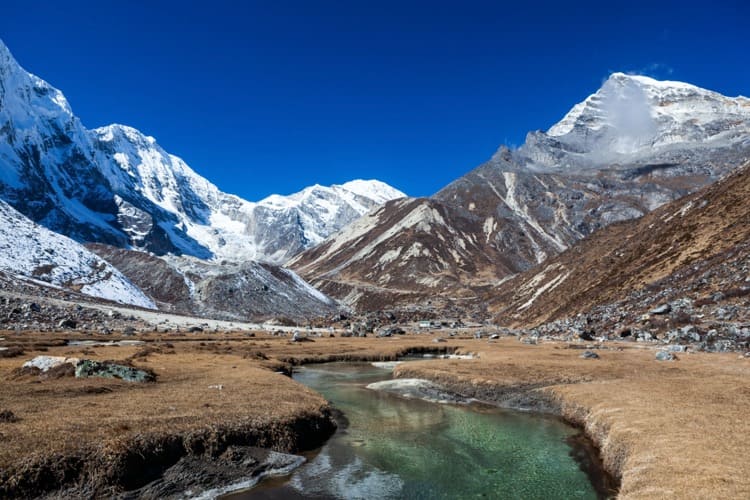
In the Rowling Valley, the landscape varies from lush vegetation, alpine vegetation, raging rivers and cascading waterfalls, to grazing pastures, boulder strewn trails and steep uphills. Gaurishankar is the main mountain you will see in this area. There is wildlife in this area, ranging from monkeys at the lower elevations to snow leopards at the higher elevations. It may be difficult to spot the rarer mammals but definitely you will see yaks, many of them wild herds, on the hillside.
You will spend between 4 to 9 hours on the trail daily. The average day will be more like 6 hours. Lunch and short rest breaks are taken on the trail.
When you reach the next campsite you will be served snacks and more hot tea while you have a chance to relax before dinner. As for food, there are always vegetarian options at every meal, and (please request) some canned meat and fish for non-vegetarians.
What you will not see are hundreds of other trekkers on the trail! Rolwaling is a remote, sparsely populated area and the Rolwaling Valley is nestled in the Gaurishankar Conservation Area. The settlements you pass through are small and often seasonal.
Rivers and waterfalls are a feature of the Rolwaling Valley. Crossing rivers by suspension bridge is thrilling as is hearing the thunder of waterfalls. You will also be visiting the high altitude glacier lake, Tsho Rolpo, which is in itself a wonderful destination.
The Rolwaling Valley section of this trek is very different from other treks in Nepal – it can be damp and stark, but it is always atmospheric and beautiful in its ruggedness.
Once you cross the Tashi Lapcha Pass you are in the Everest Region. This area is, of course, home to Mount Everest and is famous among trekkers and mountaineers.
- The Culture: Overall, the people from both sides of the pass follow Buddhism. On the Rolwaling Valley side, there is a mix of different ethnic groups such as Gurung, Sherpa, Tamang, Chhetri and Brahmin. Villages are built in traditional style and often surrounded by stone walls to keep out wildlife and the high winds that occur in this area. When you cross over into the Khumbu (Everest Region) the people are predominantly Sherpa, who also follow Buddhism.
- Flora and Fauna: Among the mammals, you may see Himalayan tahr, musk deer, pika (mouse-hare), and langur monkeys. Among the larger and more rare mammals can be found the red panda, Himalayan black bear, and snow leopard. You will have to be extremely lucky to see any of the bigger animals. For those who are interested in birdwatching, some birds include Himalayan griffons, lammergeyers, blood pheasants, impeyan pheasants, and rufous-bellied tits.
- The Yeti: In 1951 Eric Shipton, who was part of an expedition to survey routes to the summit of Everest (and whose findings partly enabled Hillary and Tenzing to reach the summit two years later) photographed what was thought to be footprints of the Yeti. These footprints were found near the Menlung Basin near Mt Melungtse. Today you can see what is reported to be a yeti skull in a gompa in Khumjung village, near Namche Bazaar. We do believe that Hillary examined and debunked that theory, but it makes an interesting visit and story. Will you see a yeti on your trek?
- Gaurishankar Conservation Area: Established in 2010 the conservation area covers 2,179 km2 / 841 miles2 and is part of the Sacred Himalayan Landscape of WWF. Currently managed by the National Trust for Nature Conservation, the conservation area links Langtang National Park with Sagarmatha National Park.
- Tsho Rolpa Lake: You will visit this lake on the Tashi Lapcha Pass Trek. Its stunning turquoise waters make it quite beautiful. Surrounded by mountains and rugged landscapes, the lake is the biggest glacial lake in Nepal and is continually expanding due to glacier melt.
- Mountains: The Gaurishankar Himal range is the dominant range in the Rolwaling Valley. Mountains in this range include Gaurishankar at 7,134 m / 23,405.5 ft , Melungtse 7,181 m / 23,559.7 ft and Dorje Lakpa at 6,966 m / 22,854.3 ft. Once you cross over into the Khumbu, you will get fantastic views of Thamserku (6,623 m / 21,729 ft), Kongde Ri (6,187 m / 20,299 ft), Nuptse (7,861 m / 25,790.68 ft) and of course Mt Everest (8,848.86 m / 29,029 ft) and many more.
- Namche Bazaar: Namche Bazaar was always the market town of the area but is now a bustling center for mountaineers and trekkers. With its restaurants, cafes, bars and hotels, it is quite different than it was 70 years ago when Hillary visited. If you have time, it is only a short hike to Khumjung village where Hillary set up a school and hospital for the local Sherpa community. Other places of interest include the Sherpa Museum in Namche itself.
- Tenzing-Hillary Airport: The airstrip at Lukla is one of the highest airports in the world and quite challenging for pilots. It is an interesting experience to fly in or out of this airport and get views of the mountains from a different angle.
Minimum Number of Trekkers for this Trek
For a camping trek in Nepal, we require a minimum of two (2) trekkers to make it viable. It is also more enjoyable for you if there are more in your group.
However, if you are one person traveling alone we will endeavor, if possible, to put you with other trekkers who wish to do this trek.
In this remote area, there are very few teahouses or home stay accommodation, which is why we chose to offer a camping trek.
At our campsite we will provide you with a comfortable tent and sleeping mat, a toilet tent and dining tent. There is a kitchen tent where the camp chef will make delicious food and boil water for you for drinking.
While we try to make everything as comfortable as possible for you, make no mistake, this is rough camping with no facilities other than what we carry in with us. If that doesn’t sound like your kind of adventure, we offer plenty of other treks which do not involve camping!
As for many treks in Nepal, the best time to do this trek is during the spring or autumn.
In the spring (March to May) the rhododendrons will be in bloom at lower altitudes and the skies will be clear. On the downside, there may be some light rain at times in the Rolwaling Valley. It will also be very busy on the Everest side of the pass. On the upside, you may get the opportunity to see mountaineering expeditions heading towards Everest as spring is the main climbing season.
In the autumn (Sept to Nov), the weather is similar to spring in that it is not too warm (at lower altitudes) and not too cold (at higher altitudes). Again, this is an extremely popular time for trekking in the Everest Region. It is also the time of festivals in Nepal so there may be festival related activities happening.
During the monsoon (June to Sept) months (June to August) there will be heavy rain making the trails slippery and camping soggy!
Winter (December to March) is not recommended as there is likely to be snowfall on the pass and in other high altitude areas. The pass may in fact be closed. It will also be very cold.
Breakfast, lunch, afternoon snack and dinner are made by our lovely camp chef.
While you are getting ready in the morning, breakfast will be prepared. A packed lunch will be taken on the trail and there will be snacks and tea available at the end of the day while you are waiting for dinner to be prepared. That chef is a busy man!
As there is no electricity at the campsites the cooking is done on a kerosene stove which the camping crew will bring with them.
We suggest bringing your own snacks for those moments when you just want a taste of home or a shot of chocolate. Protein bars, dried fruits and nuts will also give you an energy boost.
Possible Menu While Camping:
Food on the trek will be simple, yet filling and tasty. We cater to Western tastes as well as to clients who may be from India or other parts of Asia. We will provide you with food we think you will enjoy! Do let us know if you have any allergies or simply do not like a certain food.
- Breakfast may be porridge with bread (probably roti – a Nepali flatbread)
- Lunch and dinner can be pasta, noodles, dal bhat (Nepali vegetable curry), pizza, etc.
- Afternoon snacks may consist of fried potatoes and popcorn.
- We will not attempt to buy fresh meat but will bring some canned meat / tuna fish. There is no guarantee the meat in remote areas is indeed fresh, which is why we will not buy it.
- There will be vegetarian food available at every meal.
- Tea/ coffee/ hot water is unlimited. Powdered milk and sugar are available.
We will not carry alcohol as we do not recommend its consumption at altitude. And it’s simply too heavy to carry. Same with soft drinks – too heavy to carry. You could bring some flavored powder to add to the water for a different taste.
Drinking Water While Camping
The kitchen tent will provide you with boiled water for drinking. If you come across a mountain spring, as long as you add purifying drops or tablets to it you can drink that water. When in doubt ask the guide. A Lifestraw will filter out some, not all, larger bacteria so if you have one, bring it along.
What You Need to Bring for a Camping Trek
Take a look at our list of trekking equipment / gear you need on any trek. We suggest a few additional items for a camping trek, such as:
Your favorite snacks.
- Portable solar panel (one which hooks onto your day pack) to recharge equipment.
- Headtorch with batteries and extra batteries.
- Medicines – any ones you take regularly plus items such as headache tablets, stomach tablets etc. And a small first aid kit.
- Four-season sleeping bag. This can be rented in Kathmandu.
- Toiletries in small, travel sized containers, and some clothes washing soap.
- Things for blisters and a few bandages in case of sprains.
- Nepali rupees in case there is something you wish to buy on the trek.
Want to read later?
Download the PDF and read it later.
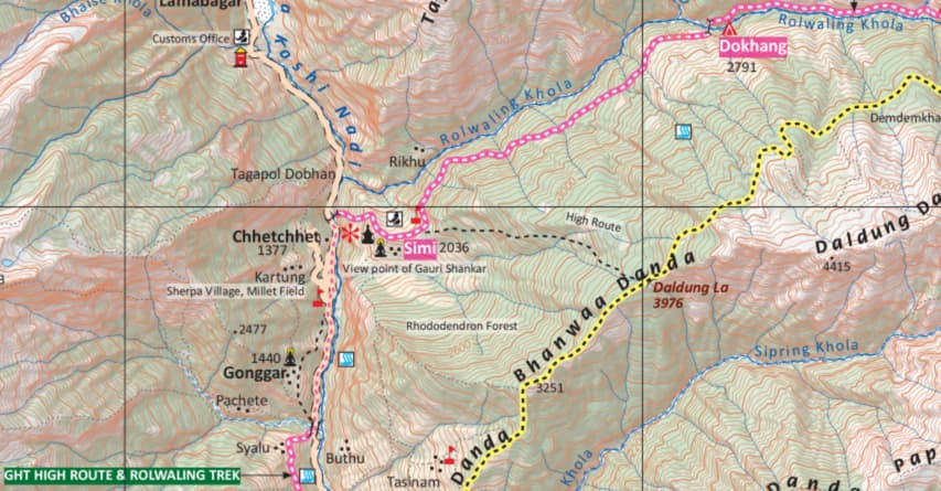
Tashi Lapcha Pass Trek Map